Mills & Millers
A comprehensive map of the great majority of mills in NI, including those mentioned here, can be found on the Mills of Northern Ireland website.
Historically, local mills were essential for any rural community; the roads were poor and transport was difficult and expensive; what was produced locally needed to be processed locally. The most basic need was for grinding of grain—oats and wheat—for flour, or milled more roughly for animal fodder. The most usual ways of powering grain mills were by wind or by water. There were also scutch mills used to process dried flax and separate out the useful fibres.
Windmills
Poyntzpass has one very obvious former mill, long referred to locally as ‘the windmill stump’1[8] which sits on the top of Tullynacross hill, about 1/3 mile from the village centre. John Campbell reckons it was built about 1690, and we know that it was already derelict by 1831, as it is shown without sails on Alexander Richmond’s the sketch of the village.
Why was the Tullynacross windmill abandoned? The most likely explanation is the development of the water-powered mills on the river just west of the village; water was more reliable than wind, and grain did not have to be carted to and from the top of a high hill.
John Roque’s map of 1760 shows another windmill, at Aughantaraghan, but there is no obvious trace of it now, either on the ground or on contemporary aerial photographs.
Water-Powered Mills
Off Markethill Road
According to the OSMI: (year)
“A flax mill situated…near the above-mentioned corn mills is [also] the property of Alexander Crothers. The following are its dimensions; nature of wheel – breast, diameter 16 feet, breadth 3½ feet, fall of water 19 feet. Water wheel and works of metal…situated in the townland of Brannock.”
“There are two corn mills situated a quarter of a mile to the westward of Poyntzpass, on a by-road. They are both the property of Alexander Crothers. The first is in the townland of Tullmakross. Their dimensions are as follows: first mill, nature of wheel – breast, diameter 10 ft, breadth 3 feet, fall of water 17 feet, works of wood, 1-storey, in good repair; second mill, in townland of Brannock, nature of wheel – breast, diameter 15 feet, breadth 2 feet, works of wood,…
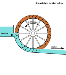
The figures quoted for the fall of water are puzzling; for a breast-shot water wheel, the fall is typically half the diameter of the wheel, as shown in the diagram.
All of the above mills seem to have been later acquired by John Bennet.
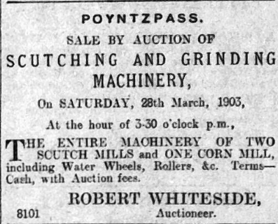
It seems that the mills stopped operating in the early 1900s. On 26th March 1903, the mill equipment seems to have been auctioned.
There are many newspaper reports of scutch mills being destroyed by fire, such as that belonging to Falkiner B Small in February 1915. This is not ardly surprising, given the flammable nature of what they processed and the fact that most artificial lighting still used oil lamps.
Near Gamble’s Bridge
The next closest mills to the village were those just off the old Newry road, near Gamble’s Bridge.
Location: ///palaces.attitudes.teacher
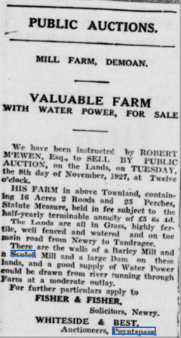
According to this advert from almost 100 years ago, there were two mills on the site, a scutch mill and a grain mill. However, they were already derelict by 1927.
The water supply came from a very large mill pool, which was in turn fed by Hare’s Bog.
Frank Watters, local historian extraordinaire, talks about the history of the mills on the site between five and ten minutes into this video.
Jennifer Steen, whose family own the site, has kindly provided the following photographs, showing the ongoing work to stabilise the buildings on the site, and prevent further deterioration.


- See “The Windmill Stump”, John Campbell, BIF Vol 10, 2009 and
“Mavemacullen – The River Cusher And its Mills” by Harry O’Hare, BIF Vol 2, 1988. ↩︎